



Excessive rain, now becoming more frequent due to climate change, may not be the only cause of the devastation in Upper Assam. Human activities such as excavations and deforestation could also have played a role.
At least 66 lives lost in around a week, close to seven lakh people affected and the government yet to reach more than 50,000 people for relief — Assam is in the grip of an unprecedented wave of floods.
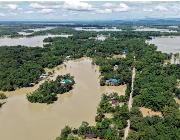
The people who live in the three most affected districts — the Upper Assam districts of Sivasagar, Charaideo and Jorhat — say they have never experienced such flooding in their lifetimes, as the devastating waters spread to new parts of this region each day.
What is the extent of the devastation so far?
With floodwaters rapidly reaching critical levels on Sunday (July 19) and spreading since then, the total population affected is now estimated at seven lakh across 856 villages in 12 districts.
Entire villages, vast expanses of agricultural land and major towns such as Sivasagar have been inundated with water well above chest level.
Since Monday, the Assam State Disaster Management Authority has recorded 58 deaths, including that of six children. But authorities have pointed out that it is very likely that this toll will rise as the full extent of the destruction unfolds.
More than 1.15 lakh people are in relief camps and around 4,455 have been evacuated from flooded areas in boats by the NDRF, Army, SDRF, Fire & Emergency Services and local administrations.
Critically, Chief Minister Himanta Biswa Sarma that the government is yet to be able to reach around 30% of areas in Nazira Assembly constituency and around 20% in Sivasagar constituency, both in Sivasagar district, even after water levels have come down.
This, he said, is because of the receding floodwaters leaving behind layers of sediment several feet high, making it difficult to access these areas either by foot or vehicle.
Through the course of the week, the Brahmaputra tributaries that flow through this belt have been flowing well above their “danger levels”. As of Friday, the rivers Dikhow in Sivasagar, Disang at Nanglamoraghat and Dhansiri at Numaligarh were all flowing at “severe flood situation”.
What were the weather events leading up to this flooding?
The Assam government had initially attributed the flooding to a “cloudburst” in the neighbouring hill district of Mon in Nagaland on July 19.
A scientist at the Meteorological Centre Kohima, however, told The Indian Express that the area had not experienced a cloudburst — which the India Meteorological Department defines as rainfall exceeding 100 mm within one hour — but rather heavy rainfall of 137 mm over the course of eight to nine hours on that day. This had also triggered multiple landslides in Mon, leaving nine people dead.
The Assam Chief Minister that the rainfall received over the course of July 18 and 19 in the three Nagaland districts of Wokha, Mokokchung and Mon and the foothill district of Charaideo in Assam was well over “normal levels”, with a 436% departure in Charaideo and 493% in Mokokchung.
He said the speed at which water levels rose because of this was “unprecedented”, which he cited as a challenge for effective response, and that the already swollen level of the Brahmaputra has hindered the drainage of these tributaries into the river.
In general, experts agree that with climate change, high intensity rainfall events of more than 50 mm or 100 mm in one day, which cause damage and floods, are becoming more frequent, and will increase in coming years.
Is only heavy rainfall responsible?
Gauhati University professor of Geography Dhrubajyoti Sahariah, who is studying the current wave of floods, said there has indeed been excessive rainfall.
“While we are still studying, there is a mix of rainfall and anthropogenic factors. One contributing factor can be that in satellite images, we have seen excessive excavation on the river valley sides, down which the rivers come, likely because of mining. It is completely dug up, which would mean a large amount of mud flowing down which reduces the river carrying capacity,” he said.
Nayan Sharma, who is a retired professor from IIT Roorkee specialising in water resources and river engineering, said he believes there are several critical contributing factors, among which is deforestation.
“Where there are heavily forested areas, when there is heavy rainfall, it increases what we call ‘infiltration opportunity time’, which means that it enables time for the water to infiltrate and percolate the ground. But if the ground is barren, the water doesn’t have enough time to percolate and it moves downhill very fast and carries a lot of silt. Which is what we’re seeing, with a rapid loss of forest cover. This excess silt then raises the river bed and reduces carrying capacity,” he said.
“We need 100% afforestation in watershed areas,” he said. He also said that he believes more effective forecasting using global precipitation monitoring systems would not make the scale of destruction “inevitable”.
Sahariah said that the release of excess water from the Doyang Hydroelectric Project in Wokha had not helped floodwaters recede.
Source: https://tinyurl.com/msfw689t